High seismic risk zone in Himalayan region
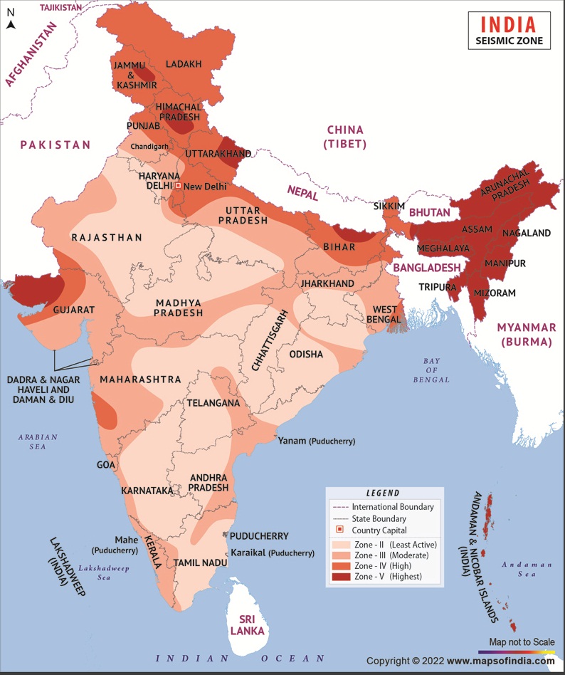
Seismic zones in India are regions that are classified based on the likelihood of earthquakes occurring in the area
Post by MOHAMMAD HANIEF on Sunday, July 30, 2023
Various organizations of government of India are involved in seismic zonation mapping and regular monitoring for identification of high seismic risk zone prone areas across the Country in order to mitigate their effect.
The national centre for seismology under the ministry of Earth Sciences monitors the earthquake activity in and around the Country on 24x7 basis with special emphasis to the Himalayan regions having high seismic potential. Wadia Institute of Himalayan Geology under the Department of Science and Technology has about 70 broadband seismograph stations operational in the Northwest and Northeast Himalaya for monitoring earthquake activities, evaluation of seismic hazards, and earthquake precursory studies.
Since, an earthquake can trigger landslides, landslide susceptibility and vulnerability maps by incorporating tectonic activity based on machine learning algorithms have also been prepared. This information was given by union minister of state for environment, Forest and Climate Change Ashwini Kumar Choubey in a written reply in the LokSabha on July 24, 2023.
The Indian Space Research Organisation (ISRO) has carried out landslide susceptibility zonation mapping along with Northwest and Northeast Himalaya. ISRO has also established a network of 30 Global Navigation Satellite System based Continuously Operating Reference Stations across Himalayan belt to monitor the process of crustal deformation. In addition to above, the Geological Survey of India (GSI) has carried out research and development studies with field validation across the landslide prone areas of the Country. GSI has also installed permanent Global Positioning System (GPS) stations in different parts of the Country with an aim to monitor plate movement and also map areas with strain in homogeneity. GSI has established Seismo-Geodetic Data Receiving and Processing Centre which receives and processes real time Seismo-Geodetic Data from Remote Broadband Seismic Observatories located in various parts of the Country.
The information on seismic activities recorded by these organizations gets disseminated to all stakeholders including state and central disaster management authorities for use in regional development planning of hill areas and further research studies for use in the management of seismic disasters in the Country.
In order to protect the environment including mountain ranges, the Government of India has adopted the National Environment Policy in 2006. The Policy recognizes the role of mountain ecosystems in maintaining the ecological balance of the region and emphasizes upon to promote appropriate land use planning and watershed management for sustainable development of mountain ecosystems. The Ministry of Environment, Forest and Climate Change has established the Govind Ballabh Pant National Institute of Himalayan Environment as a focal agency to advance scientific knowledge and to evolve integrated management strategies for conservation of biodiversity and natural resources in the Indian Himalayan Region. Among other initiatives, the National Mission for Sustaining Himalayan Ecosystem under Department of Science and Technology aims at evolving management measures for sustaining and safeguarding the mountain ecosystem.
The National Remote Sensing Centre has prepared a Landslide Atlas of India in 2023 that shows landslides occurred during 1998-2022 within the hilly regions of India. The database covers landslide vulnerable regions in 17 States and 02 Union Territories of India in the Himalayas and Western Ghats. This landslide database was used to rank 147 hilly districts of India in terms of their exposure to landslide risk in terms of key socio-economic parameters. The database also highlights the advanced techniques in landslide detection, modeling and prediction.
Seismic zones in India are regions that are classified based on the likelihood of earthquakes occurring in the area. The classification of Seismic zones in India is done by the Bureau of Indian Standards (BIS), and other agencies are the European Mediterranean Seismological Centre (EMSC), and the United States Geological Survey (USGS) which help in determining the design and construction standards for buildings and structures in different parts of the country.
For example, in high-risk seismic zones, building codes may require the use of stronger and more flexible materials, such as steel and concrete, and the structures may need to be designed to better withstand the forces of earthquakes. It’s important to note that the seismic zones are not static and can change over time as new data is gathered and analysed. Therefore, it’s crucial for building design and construction to take into account the latest seismic zone information and follow the appropriate standards for the area.
Seismic zones are determined based on several factors, including the historical record of earthquakes in the region, the type of geology and tectonic activity, and the level of seismic risk. The seismic zones are typically classified into several categories, with the most seismically active zones being designated as high-risk areas, and the least active zones being designated as low-risk areas Seismic zones form due to the movement of tectonic plates that make up the Earth’s crust. The Earth’s crust is broken into several large plates that move and interact with each other along plate boundaries. When two tectonic plates move away from each other, this is called a divergent boundary, and when two plates move towards each other, this is called a convergent boundary.
At a convergent boundary, one plate is forced beneath the other and is forced down into the Earth’s mantle. This process is called subduction, and it is at these subduction zones where most of the world’s largest and most destructive earthquakes occur.
The locations where earthquakes are most likely to occur are known as seismic zones, and these areas are typically associated with plate boundaries and areas where the Earth’s crust is undergoing significant deformation. Seismic zones can also form near active faults, where two blocks of the Earth’s crust have moved past each other along a fault plane.
The origin of seismic zones in India is primarily due to the tectonic activity associated with the collision of the Indian Plate with the Eurasian Plate. The Indian Plate, which began moving northward from the Southern Hemisphere about 50 million years ago, collided with the Eurasian Plate about 40 million years ago and continues to do so today. This collision has resulted in the uplift of the Himalayan Mountain range and the formation of the world’s highest peaks, including Mount Everest.
The collision of the Indian and Eurasian plates has also resulted in the formation of several active faults and fault zones that run through the Himalayas, the Indo-Gangeticplain, and other parts of the country. These faults are capable of producing large earthquakes, and the surrounding areas are considered to be seismically active.
(The author is a regular columnist and can be mailed at m.hanief@gmail.com)