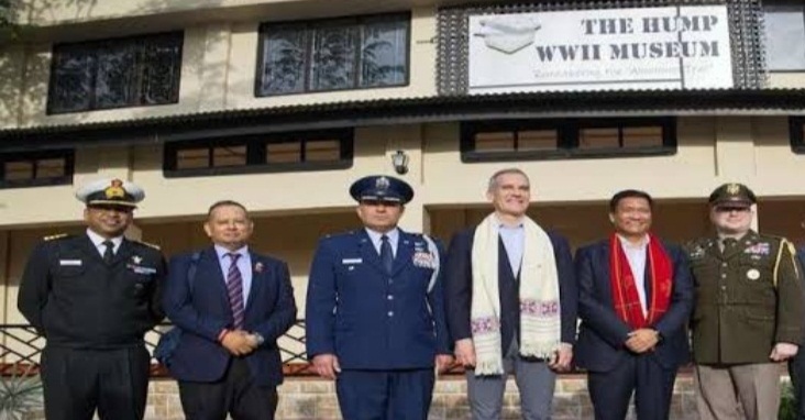
The Hump 2nd World War Museum: An Ode to the Missing Air Warriors in Arunachal Pradesh
“The most dangerous, terrifying, barbarous aerial transport run in the world”---Theodore White
Post by COL SATISH SINGH LALOTRA on Friday, January 5, 2024

The above quote of noted historian ‘Theodore White’ summarizes the cynicism which had crept into most people and that of the force operating on this ill-fated ’Hump route’ in NEFA(Arunachal Pradesh) during the airlift operation that crossed the Himalayan frontiers into china during the 2 WW. Welcome to one of the most dangerous aerial routes in the world which a pilot faced during that period and even today dreads to fly over. A piece of scattered history about a monumental aerial feat got a permanent address in the ‘Hump WW II Museum’ that Arunachal Pradesh has unveiled in East Siang district’s Pasighat ,the oldest town of the state. This extraordinary aerial museum is housing the recovered remnants of the US aircrafts that met their final fate in the eastern Himalayas while valiantly flying supplies to the Chinese national army of KMT under the command of General Issimo Chang ki sheik fighting the Japanese during the 2nd WW. The ‘Hump area’ as one looks at the map of eastern Arunachal Pradesh starting ‘Diphu pass’ till ‘Yaja’is considered as one of the most hazardous flying areas by most of the air forces of the world including the IAF. The physicality of this eastern most part of Arunachal Pradesh with its raised center resembles like a hump, hence the moniker attached to this remote region of India.
A brief rundown of the difficulties on this ‘Hump route’ is necessitated here to put the readers in the right frame of mind to appreciate the humongous efforts put in by the pilots to overcome these physical cum natural barriers that sends shivers even today into the spines of best of pilots. The foothills of Himalayas rise more than 15000 (fifteen thousand feet) from the upper Assam plains in a mere short distance of few kmstouching Arunachal Pradesh ,which give the pilots a very tight leeway after taking off from upper Assam in maneuvering their aircrafts to a desired height and angle. In 1942 after the Japanese blocked the 1,150 km Burma road ,a mountain highway connecting ‘Lashio’ in present day Myanmar and Kunming in china ,the US led allied forces conducted one of the largest and longest ever air lifts in aviation history transporting nearly 6.5 lakh tonnes of supplies, including fuel, rations &ammunition to the fighting Chinese troops .
Allied aircrafts flew close to 500 miles air route from airfields in Assam like Chabua, Dinjan, Doom Doomaetc to Kunming winding their way through theuntamed terrainof present day Arunachal Pradesh. These transport pilots often plodded at about 250 to 300 miles per hour, while the winds lifted their planes to more than 25000 feet and then back to 7000 feet shortly thereafter. Between April 1942 and August 1945, more than 1600 airmen and about 600 transport planes disappeared into the daunting mountains and forests on either side of the Hump—swallowed by the unforgiving landscape and extreme flying conditions. The famous US defence secretary Robert McNamara of the 1960s/70s was one of the few lucky pilots for having flown as a transport pilot during those ill-fated air lift operations and having survived the war to tell his part of story in the famous movie—‘Fog of war’. Another moniker that this aerial route earned during those war days was ‘Sky way to hell or even the ‘Aluminum trail’ for leaving such a vast number of plane wreckages in these jungles of Arunachal Pradesh.
Although the Chinese national aviation corporation (CNAC) ran through this route before the war and its pilots continued to run cargo over the Hump, the USAF pilots were not all that well versed with the horrific terrain that was found obtained in this part of the world. Cut to the present times, the Hump aerial route assumes all the more importance, since it is this aerial route which the present day pilots of the IAF would have to embark upon taking off from the air bases in upper Assam located at Tezpur, Jorhat ,Chabua, Mohsnbarie etc for going on their missions in southern Tibet/Yunnan province of China. Readers will well remember that about 4 years back in June 2019, an AN-32 transport aircraft of the IAF went missing after taking off from Jorhat airbase for Menchuka forward landing ground. The aircraft it seemed was affected by the sudden down drafts of the weather prevailing over there. Similarly in April 2019 a wreckage of US B-24 bomber was found at Roing in Arunachal Pradesh, all kind courtesy this ‘Hump route’.
The museum project for the Hump victims is being headed by the CM Pema Khandu with active support from the US DPAA (Defence POW/MIA accounting agency) which is at the forefront of retrieving the wreckages and even the dead bodies of US servicemen since the end of 2 WW. The US ambassador to India will be invited for this seminal museum that has few parallels in the world. During my service years with the SFF (Special frontier force) in the early 1990s I had the unique opportunity of flying on this Hump route with the ARC (Aviation research center) hepters while posted at Menchuka and been first hand witness to these treacherous mountains. It is hoped that India too takes a cue from such American efforts and gives it’s due to hundreds of its servicemen buried in foreign lands as a consequence of two world wars that the Indian army fought for its colonial masters.
(The writer is a retired army officer and can be approached on his email..slalotra4729@gmail.com)